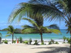
ISIMANGALISO Wetland Park has launched a new and improved map to enhance its visitors’ and stakeholders’ experiences.
It comprises six other maps for visitors, an overview of iSimangaliso Wetland Park, a map of Eastern and Western Shores, uMkhuze, Lake St Lucia Estuary, Kosi Bay and Sodwana Bay.
The map aims to provide better navigation for visitors, helping them locate all the sites and showing where accommodation, picnic sites, campsites, reefs, restaurants and petrol stations are. It also lists the distances between destinations and advises roads to take.
Andrew Zaloumis, ceo of iSimangaliso Wetland Park said: “We hope that with the aid of this map, visitors will enjoy their stay at the park and will take with them a different and unforgettable experience.”